Bribie Island, Australia
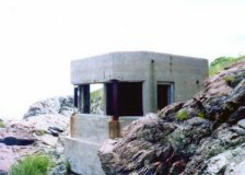
Oban Bay, Scotland
Nahant,
Massachussetts
AROUND THE WORLD
This is the home page for the anti-submarine magnetic indicator loop research project. Indicator Loops
are long lengths of cable laid on the seafloor of harbours to detect enemy
submarines. They were developed by the Royal Navy in the early 1900s and first trialled at the end of WW1.
They were then successfully deployed in WW2 in
British ports both at home, in the Dominions (Australia, Canada, New Zealand,
South Africa, Kenya, Ceylon, Penang) or in allied harbours (Iceland, Holland,
Dardanelles). By 1942 the United States had adapted this technology for its own needs.
If you have any feedback please email me: wald ingr49 @yahoo.com.au
VIDEO
Indicator Loops - an overview (YouTube, 70 minutes)
TECHNICAL
How an indicator loop works
Reading a US Navy loop signature
Who made the Loop cables? Harbour Defence ASDIC (HDA)
John Caldecott FRS, and Alexander Crichton
Mitchell FRSE - geomagneticians of note.INDICATOR LOOPS AROUND THE WORLD Royal Navy
Overview of Royal Navy loop stations
Oban (Argyll, Scotland)Isle of May (Firth of Forth, Scotland)Bereshaven & Queenstown (now called Bere Is. and Cobh, Ireland)
Cromarty (Moray Firth, Scotland)
Portballintrae and Orlock (Antrim, Northern Ireland)Loch Ewe (North West Scotland). Guard loops
and Controlled Mining only.Sheppey Island , Kent)
- Shellness and Sheerness: Guard loops and Controlled Mining at only.
Scapa Flow, Orkney Isles Plymouth
The Solent: Portsmouth & the Isle of Wight - Hatherwood, Bouldnor, Bembridge, Culver, Nab Tower, Horse Sands Fort, No Mans Fort, Portsmouth
Portland (HMS Osprey)
Penang Cumbrae Rosyth Dunoon Trincomalee (Ceylon)
Crete (Suda Bay) Greece
Malta
Haifa Palestine (Israel)
Alexandria (Egypt)
Algiers (Algeria, North Africa)
Dardanelles (Turkey)
Bosphorus - northern end (Turkey)
Smyrna (now Izmir, Turkey)
Hong Kong
Singapore
Walcheren Island - Flushing to Breskens (Netherlands)
South Africa (Capetown, Durban, East London, Port Elizabeth)
Mombasa , Kenya: in Kilindini Harbour
Manza Bay , Tanga, Tanzania Iceland (Hvalfjordhur
or Hvalfjordur)
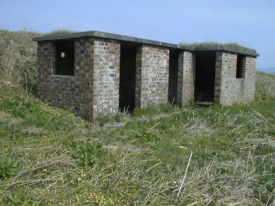
Royal Australian Navy Moreton Bay Harbour Defences.
These were located at several
naval installations in and around Moreton Bay as follows:
RAN 2(A) : Controlled Mining and Guard Loop Station at Tangalooma;RAN 2(B) : Controlled Mining and Guard Loop Station at
Fort Bribie;RAN 3: Controlled Mining and Guard Loop Station at
Cowan Cowan;RAN 4: Indicator Loop and Harbour Defence ASDIC Station at Woorim, Bribie IslandRAN 7: Indicator
Loop and Harbour Defence ASDIC Station at Comboyuro Point, Moreton Island;RAN 9: Indicator Loop and Photo-electric beam Station, Myrtletown;Also of interest: Fort Bribie , including RAN 2 Controlled Mining Station.
Fort Skirmish , Woorim,
Bribie Island (Skirmish Battery)Toorbul Radar
Station No. 210 run by the RAAF
Sydney (Loops, HDA, PE Beam) Fremantle (Loops) Darwin (Loops)
Newcastle (Loop and Controlled Minefield) Port Phillip
- Victoria (PE Beam) Broken Bay (Loops and Controlled Minefield) Port
Kembla (Loop) Port Stephens (Loop) Botany Bay (Controlled Minefield)
Port Moresby (Indicator Loops); Port Moresby Guns (Gun Battery remains)Royal New Zealand Navy
Auckland, Wellington & Christchurch
Royal Canadian Navy
Overview of indicator loops in CanadaSaint John
Antisubmarine School at Digby (Nova Scotia) Prince Rupert (Port Edwards)
United States Navy
Casco Bay (Portland,
Maine): 1A Bailey Island, 1B South Portland (Cape Elizabeth), 1F Peaks
Island/Fort William
1C North
Scituate (Fourth Cliff to Provincetown, Massachusetts); and Rhode Island
(Massachusetts)
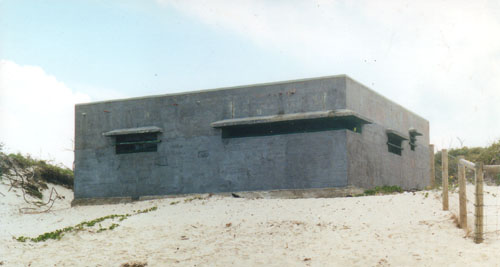
1D Nahant, East Point (Boston,
Massachusetts)
1E Gloucester, 25 mi N of Boston (Massachusetts)
1G Portsmouth (Appledore Island,
Maine)
1H Fort Burnside
1I South Westport at Gooseberry Neck (or Westport Point); Mishaum Point HECP (Massachusetts)
1X Argentia - Naval Base (Newfoundland)
Fort Tilden (New York) Harbor Entrance Control Post (HECP #2)Fort Hancock (New Jersey) HECP #1, Sandy Hook (& Spermacetti Cove). Combined webpage with Fort Tilden.Fort Wadsworth HECP, Staten Island, New York. Not a loop station but an administrative centre for HECP1 and 2.
Fort Wright - Fishers Island (HECP) Fort Miles on Cape Henlopen near Lewes
Ocracoke Naval Station (North Carolina)
Panama
Woody Island , Kodiak (Alaska) Cable laying ship USCG Pequot