
ROYAL NAVY HARBOUR DEFENCES - ISLE OF SHEPPEY
ROYAL NAVY
HARBOUR DEFENCES - ISLE OF SHEPPEY
 |
 |
 |
| Shellness XDO Post | Minster Submarine Boom | Sheerness XDO Post |

 |
If you have any feedback please email me: Dr Richard Walding Research Fellow - School of Science Griffith University Brisbane, Australia Email: waldingr49@yahoo.com.au |
Photos marked [PP] are courtesy of Paul Prior, Kent History Forum. (search "Shellness XDO"). Email: paulsmailuk@yahoo.com
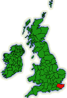
KENT
Kent is a beautiful and fertile country with mild climate
and flourishing agriculture. It has some of the finest farming land in England
especially on the banks of the Medway and Thames Rivers. The Medway River separates into two branches either
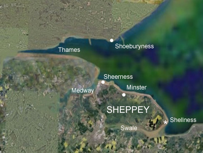
side of the Isle of Sheppey: the East Swale and the West Swale. Shellness is at
the mouth of the East Swale and Sheerness is on the West Swale at the mouth of
the Medway (see map below). They both flow into the Thames estuary.
SHELLNESS & SHEERNESS
The Hamlet of Shellness is a small coastal settlement on the
most easterly point of the Isle of Sheppey in the Borough of Swale in Kent,
England, north-east of Harty and south-east of Leysdown-on-Sea. "Isle of Sheppey"
(or Scaepige)
means Island of Sheep and for centuries, the only access was via King's,
Harty or other ferries. The beach at Shellness, not surprisingly, is made
entirely of shells and visitors have told me that it feels almost too delicate
to walk on as every footstep crunches the beach to a finer dust. The beach is
backed by low-lying coastal grazing marsh. If you stand at the water's edge you
can see across the Swale to Whitstable and Seasalter on the mainland. Shellness
marks the end of Sheppey proper as you can see from the aerial photo below. If
you continue along the beach you will reach the Royal Society for the Protection
of Birds (RSPB) reserve on the marshy ground that covers the southern half of
the island. Although Sheppey appears to be one island, the marshes comprise four
other islands: Elmley, Harty, Fowley and Deadmans, the latter two small and
inaccessible with Elmely and Harty making up much of the featureless side of the
island that greets you as you cross the Kingsferry Bridge.
The Swale has always been an important waterway.
In his 1823 edition of New and Extensive Sailing Directions for the Navigation of the North Sea,
John Norie remarks of Shellness and the East Swale: the eastern end of Sheppey Island,
is an excellent harbour and a good retreat for ships losing their anchor, &c.
It is about 5 cables long from east to west, and nearly three-quarters of a mile
broad. The shore is, in general, soft mud: ships may run aground on any part
within Shellness; but the best place is Faversham Creek. From Shellness, to
about a mile above Harty-ferry, the ground is good for anchoring; and there are
3½ , 4 and 5 fathoms, at low water, spring tides; at those tides the water rises
from 17 to 21 feet, and at neap tides from 12 to 14 foot.
 |
 |
| Kent, UK. | Shellness and Sheerness are at the ends of the Isle of Sheppey. |
The land at Shellness has been owned by the Ministry of Defence
since before WW2 and has been used for training purposes and as a firing range.
There is still quite a lot of unexploded ordnance in the area. It also incorporated a
coastal Battery consisting of 2 x 6" BL MK II, 2 x DELs, 1 x 20mm, 2 x MGs and a
small Barracks. In WW2 it was an Emergency Coastal Defence Battery of which
Observation Post, Pillboxes and Gun Emplacement survive. The Barracks was used
for officers accommodation for the local Airbase. There is also an XDO (Extended
Defence officers) post which is in very good condition (see photos below). It is
rumored that it was also used as a "Z" rocket testing station but
there is no evidence for this. It is also part
of a large nature reserve that includes Harty and Elmley. A map of the various
military installations has been prepared. Click this link
Sheppey Military to see the map.
ROYAL NAVY ANTISUBMARINE DEFENCES
ON SHEPPEY
The Royal Navy had four defensive
installations on the Isle of Sheppey:
1. Sheerness Boom: a
small antisubmarine boom on the northern end at Garrison Point, Sheerness
stretching across the Medway to Grain Tower Battery on Grain Island.
2. Minster Boom: a
large boom at Royal Oak Point, Minster stretching across the Thames estuary to Shoeburyness on the Essex coast.
3. Sheerness Extended Defence Officer's Post:
on the northern end of Sheppey Island at Sheerness; responsible for the
Sheerness and Minster antisubmarine booms and Medway minefield.
4. Shellness Extended Defence Officer's Post: on the southern end of Sheppey at Shellness;
responsible for the East Swale minefield .
1. The Boom defences at Sheerness
2. The Boom defences at Minster
The Medway Boom was built at the beginning of WW1 (about 1914) and consisted of
a vast chain attached at one end to Grain Tower Fort (Martello Battery) on
Grain Island across to the southern side at Garrison Point Fort at Sheerness. It
was raised and lowered by a winch on the wharf at the Sheerness dockyards. See the map below.
The chain was removed at the end
of WW1 and the Grain Tower Fort placed into 'care and maintenance'. In WW2 twin 6pdr QF guns were installed as defence against the fast and very manoeuverable
German E-Boat.
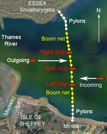
The second, and much larger boom, was installed across the Thames estuary
between Royal Oak
Point at Minster and Shoeburyness on the Essex coast. The boom consisted of a row of pylons stretching out into the sea with nets in between
and supported by large barges called lighters weighing some 200 tons. The nets were opened
and closed by three ships; one in the middle, one to its left and one to its
right. Incoming ships sailed between the left and middle ships, outgoing ships
sailed between the right and middle ships. The right hand side ship
was HMS Pallisade which was stationed five miles out of Sheerness and,
like the other boom vessels, was fitted with Horlicken guns; every 5th shell was
a tracer - they lit up the area. The Boom vessels were also fitted with ASDIC
(now known as sonar) and if a German U-Boat was detected within half a mile of the Boom
Defence a signal was sent to Garrison Point (Sheerness XDO), for a destroyer to be
sent out to sink the submarine. You can visit the Shoebury boom at the far end
of the Ministry of Defence controlled East Beach between Shoebury Garrison and
Pig's Bay. The beach is owned by the MOD, who once a year, close off public
access and fire a shot out onto the Maplin Sands to retain their firing rights.

Grain Tower Fort from satellite. Boom net chain
at bottom is clearly visible.
The boom attached by chain to Grain Tower Fort on
Grain Island across the Medway from Sheerness. Thanks Kyn for the
photo.
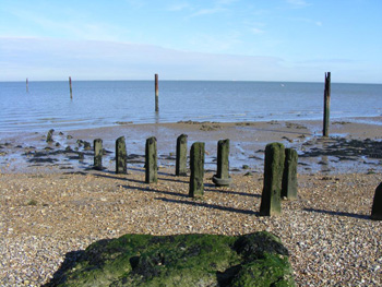

Boom pylons at Royal Oak Point, Minster. The
original hulk mooring poles are to the right. Many of the pylons
were removed in the 1960s as they were a danger to shipping. [PP].
Boom at the Essex side - at Shoeburyness. It was
built in 1944 to replace one built in 1940, 100 m to the east. It
was upgraded with concrete in 1954. Photo courtesy of Julieanne
Savage
http://www.geograph.org.uk/photo/302957.
Operation of the Shoebury-Minster Boom. Referring to the figure below
right, there are three anchored ships in the shipping channel, designated as
Left, Mid and Right. There is a single cable that runs from the "Left" ship
around a pulley on the fixed pylon "C" and to the "Mid" ship. The boom net
is attached to the cable at point "B". When the incoming ship has been
cleared for entry the "Left" moored ship would winch in cable "A" around the
pylon "C" and at the same time "Mid" ship would let the cable run out. This
would draw the boom net end (point "B") towards the pylon "C" and they would
then allow the cable to slacken and fall to the seabed. Thus the boom gate
would be open for the incoming ship. To close the gate, the reverse is done
with Mid ship winching in the cable as Left ship allows it to run out. The
end of the boom net "B" is drawn right up to the side of the Mid ship and
the gate is thus closed. A similar operation is done for outgoing ships. For
smaller booms or where shipping is less frequent, a single boom gate is
used.
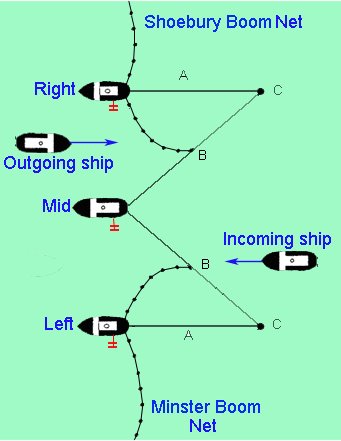
Probable arrangement for Shoeburyness-Minster Boom
Schematic for operation of the boom nets
3. Sheerness
Extended
Defence Officer's Post and Controlled Mining defences
On 27th July 1939, the Admiralty finalised its minelaying program for
ports at home and abroad for the early stages of the war should it occur.
The Admiralty policy was that minefields should only be laid at the outbreak
of hostilities and not before as the cost of maintaining the mines and the
minefield was prohibitively expensive. Minefields were planned for Hong
Kong, Singapore, Alexandria, Malta, Tynemouth and sites around the UK.
Upon outbreak of the war with Germany in September (1939) the minelaying
program began in earnest, including those at Sheerness (medway) and Shellness
(East Swale). Personnel were trained at the Controlled Mining School
at HMS Vernon (Portsmouth, England).
The Sheerness XDO Post and mine watch station is located on the northern end of Sheppey Island at Sheerness. The XDO was responsible for the
Sheerness and Minster antisubmarine booms and Medway controlled minefields.
As stated before, the Thames naval defences go back two hundred years.
But the army defences go back further; the fortification of Sheerness began in
the 1670s. Originally, many Martello towers were built to defend the Kent coast against a French invasion
between 1805 and 1808 and are a familiar sight to visitors to the south coast around Folkestone, Shorncliffe and Dymchurch. However, less well known are the three
other Martello towers in Kent built between 1850 and 1915 as part of the Medway
defences at Sheerness. They were designated the 'Centre Bastion Battery' and
were several hundred yards from the bigger guns at the Garrison Point Battery at
Sheerness. In 1937, it was proposed to transfer the heavier 6" guns
from Garrison Point Fort on the towers in place of the 4.7-inch guns, but this
proposal was never implemented. Instead the guns were removed at the beginning
of WW2, and the three buildings taken over by the Royal Navy for Thames and
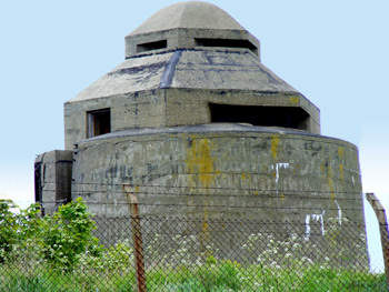
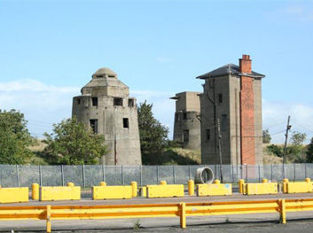
Medway defences (see photo below). Both towers (far
left and far right) had additional concrete structures built on the old gun
platforms, one of which was a standard pattern square shaped Observation Post probably for
control of nearby searchlights. The other structure on the tower (rightmost)
nearest Garrison Point Fort was an hexagonal Observation Post with a raised
dome-shaped top and was built for use by the Extended Defences Officer (XDO) who
supervised the firing of the controlled minefield laid at the entrance to the
Medway. This type of OP was known as 'Observation Minefield Control Tower-Type
E' and on the lower floor of the OP were the mine firing panel, electric
batteries, charging panel and tail resistance balancer together with a 4 feet 6 inch (1.38 metre) Barr & Stroud rangefinder
and telephone connected to XDO above.
The upper observation dome contained an open sight bearing indicator. Between
the two towers was the battery command post (BCP) which was square in shape with
a domestic-style hipped roof and chimney stack with three chimney pots, all
helping to disguise its military role. The command post was approximately 14 m
high with two doors and two windows at the first floor level at the front of the
building. All three buildings were camouflaged during WW2. By 1946,
the towers had finally been abandoned and today they sit in all their loneliness
like Easter Island warriors thinking of times passed. They are now flanked by a new
promenade on the seaside while at the rear Sheerness commercial docks encroach
more and more. Bill Clements' Medway
Martellos webpage has more details on the history and structure of the
Centre Bastion Battery. In Bill Clements words "Little has been done to protect these
structures and it can only be a matter of conjecture as to how long it will be
before further expansion of the docks brings about their demolition".
 |
 |
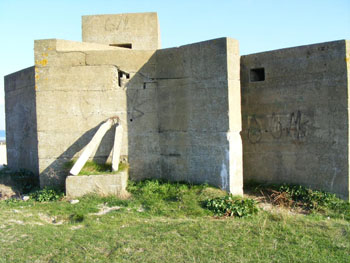
| Sheerness XDO Post. Photographer Paul Prior was kind enough to reshoot the XDO Post (on the very top) in April 2009. Thanks Paul, we owe you a beer. | Sheerness XDO Post (left) from road side. You can
see how the road corridor is encroaching on this heritage site.
Thanks Kyn for the photo. |
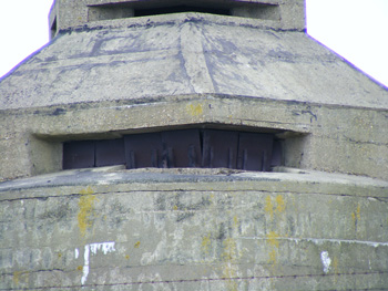 |
 |
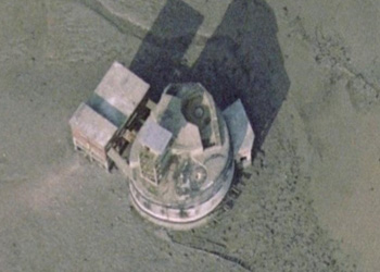
| Close-up of Sheerness XDO Post (top) and mine control room (bottom). Photographer Paul Prior thought it looked more arty to crop the top heavily but we think he should change to Foster's Light (or get his eyebrows trimmed). | Satellite photo of XDO Post and Battery Command
Post (BCP). The old 4.7" gun emplacement is on the right. The
promenade and roadway are clearly visible. |
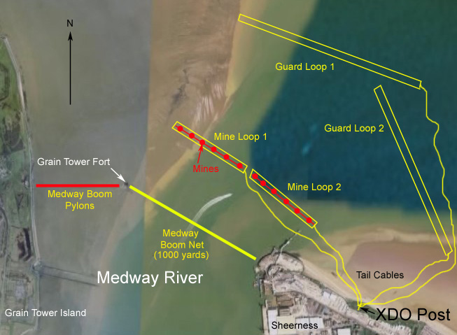 |
| Possible layout of Medway Boom Net and Guard & Mine Loops between Grain Fort Island and Sheerness. Further information is required. |
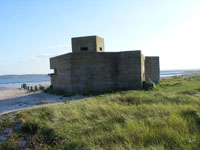
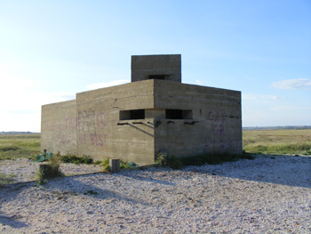
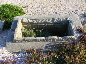
4. The Shellness XDO Post and Controlled Mining defences
-
consisted of a Extended Defence Officer's Post which doubled as a Mine Watch Station, square in
construction and made from reinforced concrete about 8 ft. high. It has an
entrance door in the east corner, which is angled slightly - presumably for
blast protection. It has two rooms: a large observation room (9' x 9') and a
smaller generator room. In the generator room, the concrete mounting pad is still there
with a door leading to the observation room and exhaust vents to the outside. The observation room has holes in
the wall for equipment and a ladder (now gone) reaching up to the
observation turret (cupola) measuring about 3 ft. by 3 ft., and about 3 ft. higher than the roof of
the building; a cube, effectively. There is a small loop-hole in each of the
four faces. To reach this turret from inside, a short iron ladder was fixed to
the floor directly beneath it, high enough (four or five rungs) to enable
observers to peer through the turret loop-holes with ease. There may have been a
small platform attached to this at some time. The observation window (shown
below) allowed direct observation and use of a Barr & Stroud telescope.
Russell Barnes' website "XDO
Posts" is a useful comparison on XDO Posts at Workington Dock and Kingswear
Castle (Devon).
 |
| Possible orientation of the Guard and Mine Loops showing how the controlled mines may have been positioned. It seems likely that there would have been two overlapping Guard Loops and four Mine Loops arranged in an echelon pattern. The Coastal Battery is also shown (but there's not much left today); and the Coastal Artillery Search Light (CASL) emplacement is also marked. |
 |
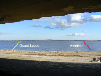 |
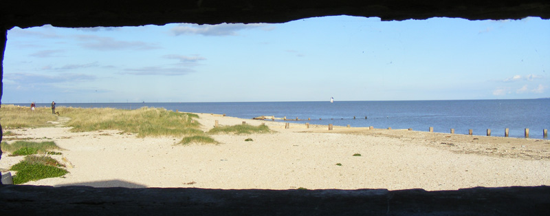
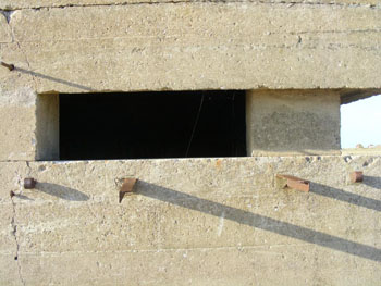
| The XDO Post at Shellness. The front face (on right) faces north-east. See floor plan at end. [PP]. | Looking through the viewing slot south east over The Swale to Whitstable. [PP]. |
 |
 |
| Rear entrance. Wall of generator room. [PP]. | The entrance. The white things to the left are just old fence posts. Nothing important. [PP]. |
 |
 |
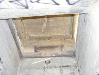
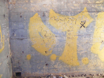
| Hatch up to turret. Ladder bolts can be seen. The ladder was quite short with four or five rungs to enable a watchkeeper to peer through the slots in the top. [PP]. | Generator slab and usual graffiti. [PP]. |
 |
 |
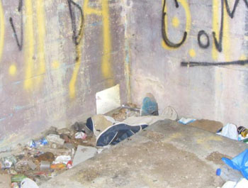
| Observation window facing SE. The brackets supported a steel hatch that could be closed in the event of attack. [PP]. | The structure in 1980. It was being used as a marker for a motor boat race. Note the steel hatch on the front. [PP]. |
 |
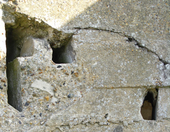 |
| Note the holes in the wall where electrical equipment was mounted. Four galvanometers are likely to have been used. [PP]. | Holes in the entrance wall for tail and power cables. [PP]. |
 |
 |
| Pit near the XDO MWS hut. Dave Wood has informed me that this is a small magazine for two inch rockets. It was part of a system named 'Radiator'. There are a number of these in Suffolk and there should be a large block of concrete nearby which the rocket firing rig/weapon was situated. [Photo by PP]. | Armoured tail cable emerging from the "shelly" beach. [PP]. |
 |
|
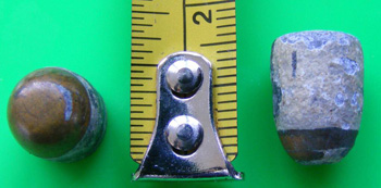
| Two projectiles found at Shellness by Paul Prior. He says that the bad stuff is taken away or blown up by the Royal Engineers. Averages about 2 unexploded AA shells,1 mortar shell a week and 1 UXB and or 1 Mine a month. [PP]. |
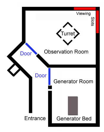 |
| Floor Plan of Shellness XDO Post. |
OPERATION
OF The Extended Defence Officer's
POST & Mine watching STATION.
The XDO was the naval officer responsible for
all naval activity in a given area. He had the responsibility for the
minefield, boom nets and signals and was the liaison between the RN and army
at the Garrison Point Fort at Sheerness. If the XDO's visual sightings and
communication with the army revealed the likely presence of an enemy U-Boat,
the XDO would give orders to the mine watch officer on duty. The orders and
firing sequence were the same throughout all CM stations around the world.
The men in the MWS had to perform daily and weekly tests on the equipment to
make sure it was in good working order and had to record perturbations ("perts"
- the swings of the galvanometer spot due to the tides) every 5 minutes to
the hour. These had to be recorded in the log book. At the end of each
watch, the Handbook of Controlled Mining Confidential Book (CB) had to be
mustered and had to be locked in a CB chest and then placed in a locked
cupboard. The guard loops were 1000 yds to the seaward side of the mine loop
so that if a submarine entered the bay it would cross the guard loop first
and alert the CM operators. If a swing was detected on the guard loop, the
operator in the MWS would close the control switch to start the 300V
generator and then ring one long bell to the power hut. The operator would
then advise the XDO "Mines to Active" and would say the number of the
guard loop (if more than one) giving the swing. He would then check to see
if the correct voltage was showing on the voltmeter. Then they had to wait.
If a swing was detected on the mine loop after a swing on a guard loop it
meant that a submarine had passed over the loops. The operator would then
report to the XDO "Mines to Active" again, shift the selector switch to the
number of the mine loop involved and fire the mines as the galvanometer spot
crossed it's zero after it's first displacement. He would then say to the
XDO "Mines to Active, mine number XX fired". After 5 seconds, the firing
release lever would be released and the selector switch replaced. If there
was just a swing on the guard loop they took no chances. The operator would
fire anyway. After a firing took place, the fuses in the mine cable would be
replaced. Of course, if a boat was sweeping for mines in the area, they
should have told the XDO of the fact.