Anti-submarine Indicator Loop stations in the United States
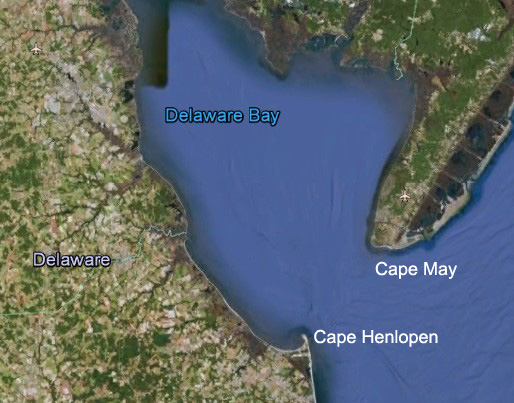
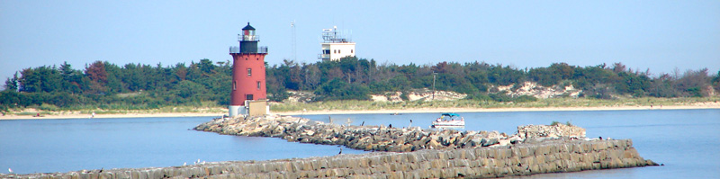
Cape Henlopen (Fort Miles) - Delaware
Drawing by Gerry Butler
Loop receiving stations, as they
were known, were operated by the United States Navy. They were used in WW2
as part of the Harbor Defenses and consisted of indicator loops, controlled
minefields, boom nets, fixed sonar (the Herald: harbor echo ranging and
listening devices).
This page deals specifically with the indicator loop antisubmarine defences
between Cape Henlopen (Fort Miles) and Cape May, Delaware, USA.
 |
If you worked there or have any feedback please email me: Dr Richard Walding Research Fellow - School of Science Griffith University Brisbane, Australia Email: waldingr49@yahoo.com.au |
LINKS TO MY RELATED PAGES:
- Indicator Loops around the World (Home Page)
- How an indicator loop works
- Indicator Loop Stations in the USA
In October 1941, the Army directed the establishment of Harbor Entrance Control Posts (HECPs) at 18 U.S. locations for the detection and defense of harbours particularly along the eastern seaboard. The full list is on my USN Loop Receiving Station webpage. In Delaware, the HECP was located at Cape Henlopen near the town of Lewes as defense for the port for Philadelphia. On 28 October 1941, the Second Coast Artillery District put the Fort Miles HECP on continuous alert. On 4 December 1941 the HECP was declared operational.
THE HARBOR ENTRANCE CONTROL POST
The Harbor Entrance Control Post was a joint Army/Navy facility providing anti-submarine harbor defenses. It monitored vessels passing through the harbor entrance and if an enemy vessel was identified by the indicator loops, the Navy would then report the loop crossing to the Army. Further, if a loop crossing was detected on the "fluxmeters" and no surface ship was detected by radar, or seen by eye, a submarine was presumed to be present. Coastal batteries operated by the Army would be called into action, along with harbor defense vessels laden with depth charges.
The captains of all vessels had to await clearance from the Cape Henlopen HECP before they could enter the bay. Waiting ships were visually identified and granted clearance based on pre-arranged challenges and responses that used simple passwords, blinking lights, and code letters hoisted in signal flags. When the HECP granted clearance, the 21st Coast Artillery was advised.
Main channels were marked with buoys and ships, with professional pilots aboard. In his book on the harbor defences of Delaware Bay*, William C. Grayson quotes Lt Cmr Walter Bennet who piloted vessels over the minefield in WW2. Bennet said that he was unafraid of crossing over the mines because he knew that the Mine Battery observers always had his vessel in their scopes. [*Delaware’s Ghost Towers, Author House, 2005, p33].
 |
|
Delaware Bay is about 200km (124 miles) SW of New York. It is the port for Philadelphia. |
 |
|
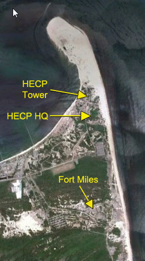
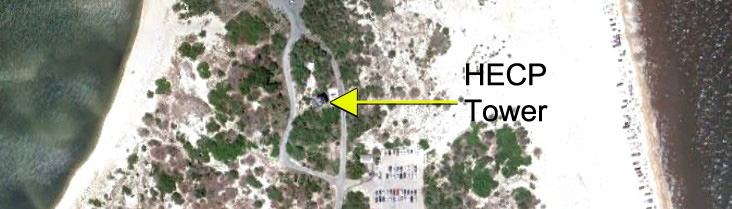
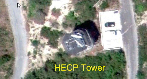
The HECP Tower (Tower 9) was about 1.7 km (1 mile) north of Fort Miles itself. The HECP Headquarters was about 290 m ( 315 yards) south of the Tower. |
 |
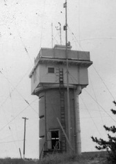
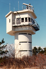
| The HECP Tower is still there today but the HECP Headquarters have long gone. |
 |
 |
 |
|
HECP in WW2 |
A close-up of the Tower and carpark from an eye
height of 55 m. (Google Earth) |
The tower today - now the
Philadelphia Maritime Exchange
Reporting Station. (Maritime Exchange for the Delaware River and Bay) |
 |
|
East End Light
and the Delaware Breakwater at Lewes Inner Harbor. In the
background is the old HECP, now the Maritime Exchange tower. Photo taken
20 August 2010. |
A full map of the guns, towers and emplacements can be seen at: Fort Miles Fire Control Network webpage (courtesy of Dan Brown - Battery 519 Restoration Volunteer).
INDICATOR LOOP LAYOUT
 |
|
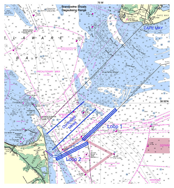
The entrance to Delaware Bay is about 18km (16 miles) wide but the main shipping channel is only about one-third of that. In this image, the location of the two Indicator Loops is shown, as well as the two controlled minefields. The yellow line indicates the wartime shipping channel that all ships - both naval and merchant - had to use. It was about 650 m (720 yds) wide. At the top, the location of the Brandywine Shoals Degaussing Range is indicated (actually just above the text). Here, US and allied ships would pass over a "degaussing range" to have their magnetic signature assessed. Based on this reading instructions would be given to the ship's commander about the currents required in their on-board degaussing coils to render the magnetic signature to zero (and thus less susceptible to magnetic mines). Note: soundings are in feet at Mean Lower Low Water. (NOAA Chart 12214) |
 |
|
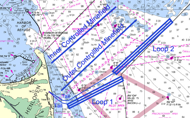
Loop 1 was 4800 m (5200 yds) long at an angle of 239º True. Loop 2 was 5800 m long (6300 yds) at an angle of 224º True. The minefields were known as "Controlled" as they were monitored and detonated from a shore station. (NOAA Chart 12214) |
The indicator Loops were laid and operational by April 1942. They were the traditional 3-legged loops with a spacing of about 200 yards between legs. The loops were much longer than the recommended 2000 yards, but in a time of crisis and shortage of materials longer loops suffice. The problem is that the longer the loop the less specific the location of an enemy submarine crossing.
CONTROLLED MINEFIELDS
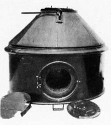
The mines being used against ships in the Delaware Bay entrance were Army Ground Mines M4. They were 90" in diameter and about 60" high. Each weighed 6000 lb and included a massive 3000 to 5000 lb of explosive. They were known as "Controlled, Magnetic Induction mines" as they could be detonated in two ways. One way is set them in "Automatic" mode where they act as conventional magnetic mines. In this case a ship's magnetisation would be sufficient to stimulate the coil and electrically detonate them automatically. The alternative is to set them in "Controlled Mine" mode where a passing ship will present a magnetic influence on a coil inside the mine which will send a electrical signal down the underwater mine control cable to the shore station where it can be indicated on the oscilloscope in the mine casement. Operators may then elect to fire the mine by sending a current (as little as 0.365 A) down a parallel wire back to the mine. These controlled mines were spaced at 30 m (100 ft) apart. Typically there were 13 mines to a group and these had their own detonation cable running back to the control station on shore. In the shore station (mine casemate or mine control hut) a motor generator provided the alternating current (AC) for firing. The rest of the mine operations used power from an 80V DC generator.
 |
|
M4 Mine with the large external coil removed. |
In the British Royal Navy controlled minefields as deployed throughout the British Isles and her dominions and protectorates (Australia, New Zealand, Canada, Kenya, South Africa, Singapore, Hong Kong) were arranged differently. The controlled mines had their own simple "guard loop" or the more complex "indicator loop" ahead of the row of mines (much like at Cape Henlopen). However, in the British system a second loop (a "mine loop") circled the mines. The guard/indicator loop would alert the loop control hut (eg the HECP) to the presence of a submarine if one passed by. When the second loop - the "mine loop" surrounding the mines - showed the presence of a magnetic field soon after, the mines would be detonated within a few seconds (enough to wait for the middle of the submarine to be overhead). At Cape Henlopen, instead of a "mine loop" the magnetic sensor inside the mine would act in the same way and send a signal back to the mine control hut on shore. At Cape Henlopen, there was a total of 35 groups of 13 mines each; 24 groups on the ocean floor and 11 inside Delaware Bay.
SONOBUOYS
The HECP also had at least three or four sono-buoy sets for detecting the sound of submarines. They were positioned inside of the magnetic loops but seaward of the mine fields. The level and Doppler effect of the sound recorded by each buoy helped track the movement of the sub.
The buoys were anchored to the bottom like the mines and positioned at an appropriate depth by a flotation device and had a protective cover. A battery powered transmitter and an antenna relayed the signal to the HECP.
THE STAFF
Although the HECP was located at Fort Miles - an Army installation - the HECP was a joint Army and Navy operation with the Navy technically in command. The HECP Officer-in-Charge was always a Navy Lieutenant Commander. The first Commanding Officer of the HECP was Lt Cmr Frank S. Carter, Sr. USNR. He was a native of Lewes and a graduate of the Naval Academy who had served in WW I and had returned to Lewes to become a prominent businessman and citizen. The initial complement of the HECP was six Watch Officers and 14 signalman to man the tower on the Cape.
The officers were selected from men applying locally for a commission. Emphasis was on finding men with former maritime experience. There was no time for indoctrination schools. They made short indoctrination trips around the Cape in small craft and began standing the watch. The headquarters battalion of the 21st Coast Artillery provided an Army liaison officer for each watch.
Lt Cmr Frank Saulsbury Carter
Frank "Pats" Saulsbury Carter Sr., son of William Purnell Carter, was born in 1889 – a 3rd generation Lewes (Delaware) resident growing up on Market Street in town. He was named after a friend of the family. Frank graduated from the United States Naval Academy in 1909. After serving in the US Navy during World War I on board several battleships, Frank started a business in Lewes in 1923 – The Frank S. Carter Insurance Company – and built a beach house on Lewes Beach at 412 Bay Avenue where he and his wife Helen (and family) spent the summers. In 1932 Frank became one of the founding members of the Lewes Yacht Club, becoming commodore in 1937 (as did his son Frank Jr. in 1949). They both raced at the Lewes Yacht Club during the 1930s. In 1942, Frank (Sr.) - this WWI veteran - was called up from the Reserves to serve as the Commanding Officer of the Cape Henlopen Harbor Entrance Control Post.
His son Frank S. Carter Jr., USNA 1942 was active in the US Navy at the same time. Frank Jr. had been commissioned as an Ensign in the United States Navy in January 1942 and served aboard the Eagle Boat PE-56 operating off the East Coast from Cape May (opposite Cape Henlopen) to Key West as German U-boat Patrol to protect the Philadelphia Shipping lanes (no doubt watched over by his father in the Cape Henolpen HECP). Frank Jr. also served aboard the USS Scroggins (DE-799) and the USS Thomas (DE-102) during the North Atlantic Patrol from Newfoundland to North Africa. He was honorably discharged from the United States Navy in 1946 as a Lieutenant Commander in the United States Navy Reserves and returned to Lewes to take over the family businesses which included the Lewes Sand Company, the Eldorado Oil Company and Frank S. Carter, Inc. Insurance Company
The Market Street house where Frank (Sr.) and Helen lived – next to Bethel U.M. Church – still has an elk stag etched in glass on the front door. It is the symbol of the Hartford Insurance Co., the company he represented when he started his Lewes insurance company in 1923. Frank (Sr.) died in 1973 and was buried at St. Peter's Cemetery, Lewes, Delaware. [My thanks to Frank Saulsbury "Nick" Carter III, for information about his grandfather and father].
END OF THE WAR
On 12 July 1945 the HECP was disestablished and harbor entrance control briefly reverted to the Coast Guard and then to the Philadelphia Maritime Exchange Reporting Station.
See also:
Fort Miles Website (batterys, towers and mines)
Cape Henlopen HECP webpage
The interpretation of loop signatures and examples can be found
at: Reading Loop Signatures.