ROYAL AUSTRALIAN NAVY
DEFENCES - FORT BRIBIE
THE RAN2 CONTROLLED MINING STATION
 |
 |
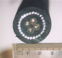 |
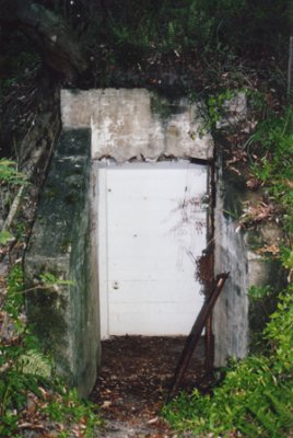
| Entrance to the Mine Hut | Banksia on the foredune | Mine cable from Bribie |
Fort Bribie was built on Bribie Island, Queensland, Australia, during WW2 as part of the Moreton Bay
harbour defences.
The Royal Australian Navy and the Royal Navy established a controlled mining
station there in 1943. For more information on
Fort Bribie itself, go to the Fort Bribie main
page.
 |
If you worked there or have any feedback please email me: Dr Richard Walding Research Fellow - School of Science Griffith University Brisbane, Australia Email: waldingr49@yahoo.com.au |
LINKS TO MY RELATED PAGES:
LOCATION MAPS
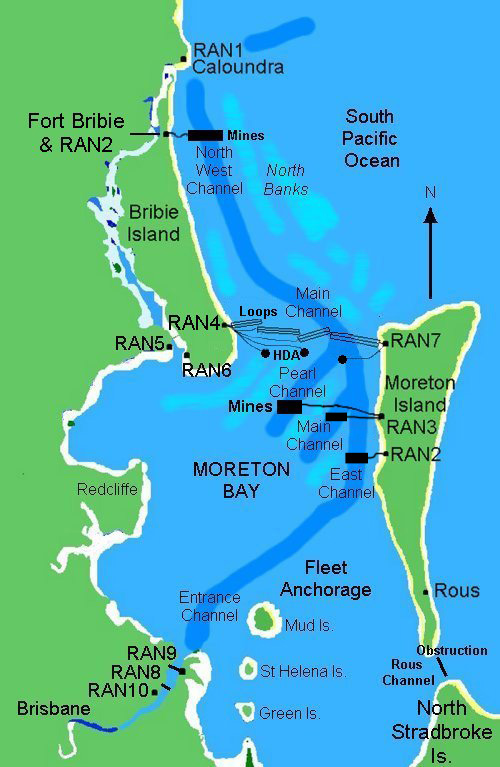
The RAN2 controlled mining station is at Fort Bribie on Bribie Island (Queensland) - half-way up the eastern coast of Australia.
 |
 |
Bribie lies at the northern tip of Bribie Island, about
25 km along the beach
from the RAN4 Station at Woorim.
INTRODUCTION
Fort Bribie was constructed at the outbreak of World War 2 as a part of the defence of Moreton Bay. Originally it was fairly primitive but as Japanese aggression increased the fort was upgraded to become the major defence installation in the Brisbane - Moreton Bay area. The map above (left) shows the harbour defences of Moreton Bay.
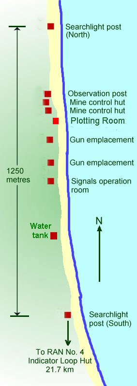
The map above (right) shows the location of the most important elements of the fort. Of particular interest to this webpage are the Mine Control Huts and the naval Observation Post. The Fort is of great historical value as it provides material evidence of the preparations for the defence of the country in World War 2. They also provide an historical record of the technology of defensive arrangements at the time of WW2. Land based defences such as these gun batteries have become outdated in the defence of Australia. Those remaining provide a vital link to the past.
They also provide a site that has been untouched since it was abandoned in 1945 and apart from the effects of natural forces they remain largely as they would have appeared after the army left the site.
A BRIEF HISTORY
As the tide of events in Europe and Asia in the
1930s moved the world towards war, batteries were improved or established in the
key areas of Sydney, Darwin and Fremantle. The defence of Moreton Bay had been
concentrated on the mouth of the Brisbane River at Fort Lytton. With the
push for rearmament of Australia's coastal defence and with the improvements in
weapons technologies, attempts were made to enhance the defence of Brisbane and
the greater Moreton Bay region. An artillery battery was established at Cowan
Cowan Point on Moreton Island between the wars and took over the role of
examination battery in the bay.
 |
|
The ocean in front of Fort Bribie on the northern tip of Bribie Island accommodates the main shipping channel into the Port of Brisbane - the biggest US Navy submarine base outside of mainland USA for the early part of WW2. Just out of view on the distant left is the northern tip of Moreton Island where the Moreton Island lighthouse is situated. |
|
|
|
A ship in the main channel of Moreton Bay as seen from the controlled mine area. |
Soon after Australia declared war on Germany in September 1939, Army personnel were moved to Bribie Island and a second six inch battery in Moreton Bay was commenced. It was only intended to be temporary and meagre resources were used in the most efficient way possible. The Royal Navy, in conjunction with the RAN established the RAN No. 2 Controlled Mining Station there in 1943. It was shifted to Fort Cowan in September 1943.
NAVAL MINE CONTROL HUTS (RAN 2)
Two reinforced Mine Control Huts were located at Fort Bribie. In planning they
were known as "Operation Duncan - Control Station No. 67". They were operated
by the Royal Australian Navy and became known as RAN No. 2 Station. The
controlled mines in the bay consisted of two mine loops, each with a "guard
loop" - essentially the same as an Indicator Loop as used at RAN4. When a
submarine was detected by the "guard loop", the operator would wait
until there was also a galvanometer "swing" on the mine loop and then the mines
would be detonated by
sending a current down the mine loop. There are thus two loops (a) the guard
"indicator" loops used for first detection; and (b) the
mine loop which is used for secondary detection and this was located directly
over the mines. Cables used included ADM Patt.
2865/4, 7408, 9610, 660. The "L" Mark 2 mine units used at Bribie consisted of
two 40" diameter mild steel hemispherical pressings 3/16" thick joined with
1/4" thick bolts. The charge was 500 lb of amatol with an electric detonator
(No. 28, Mark 2) inserted into a 1 lb charge of primer. The complete mine
and charge weighed 3151 lb (1430 kg) and could disable a submarine within a
radius of 40 feet. They had a positive buoyancy of 468 lb meaning they would
float. To keep them moored, a sinker ("L" Mark 2) consisting of a cast iron
base with a drum in the centre housing a cable that could moor mines in
water up to 25 fathoms deep.
 |
This aerial photo has the loops drawn to indicate
the position of the guard and mine loop layout. Note, however, that
it is not to scale. The loops actually were much longer and went
much further to the right. |
A brief history: The Minelayer HMS Atreus departed Melbourne on Saturday 2nd May 1942 to lay controlled mines (CM) covering North West Channel of Moreton Bay with a Controlled Mining Operation Post (CMOP) and two Mine Control Huts in the vicinity of Fort Bribie (Bribie Island Battery). The huts were not to be put in operation until a code signal "Affirmative Duncan" was despatched by the Naval Board. The CM was originally intended for Hobart but when Japan entered the war the decision was changed.
On 9th May 1942, Capt. John Campbell, Captain of the HMAS Atreus, reconnoitered the area for a suitable location for the huts and decided not to build a CMOP but to use the Battery Observation Post instead and build the the Mine Control Huts nearby. On May 10th (Sunday) Capt. Campbell landed all of the CM equipment and on the following day began the hydrographic survey of the channel and started construction of the control station. Over the period 18th to 29th June 1942, the guard and mine loops were laid. On 13th September 1943 the CM station was transferred to Fort Cowan Cowan, half way down the western side of Moreton Island. It still retained the designation RAN2. Towards the end of the war when the mines were recovered it was found that 6 were missing (1 each from the Tangalooma M1 and M8 fields, 1 from Cowan Cowan (M5 minefield) and 3 from the Pearl Channel minefield (M11). One of these was found at Tewantin on 1st March 1945 (possibly from the M5 or M8 field) but the army was quick to add that they weren't certain.
RAN staff manning the Mine Control Huts (RAN2) during WW2 were as follows:
Lieutenant (S) Michael Daniel Connaghan AB Watchkeeper(Cm) John Patrick Collins AB Watchkeeper (Cm) James Thomas Calvert AB Watchkeeper(Cm) William George Dundas Able Seaman Lennox James Ellen AB W/K (Cm) John Joseph Gillies Ldg Wireman (Cm) James Joseph Goss Wireman Albert Ernest Henry Lieutenant Douglas Henry Newman Ldg Sea (Watchkeeper) Raymond Oswald Poole Able Seaman Percival Thomas Priday AB W/K Cm William Sinclair Robson Steward Alexander Graham Reardon Lieutenant (SP) John Henry Saxe Steward Allen Vincent Stenson Cook (S) Arthur Edward Jackson Ldg Smn Watchkeeper Kenneth Vincent Norman Treloggan Lieutenant Eric Archibald Wilson
Northern Mine Control Hut
|
|
|
|
The Northern Mine Hut |
The eastern interior wall. |
Splayed
battens were cast into the walls for the wall linings and the cables
in the wall are still visible. There was a vent pipe in the ceiling for
ventilation. Drainage channels in the floor can be seen. There were 3 ceiling
lights and one wall light inside and a ceiling light in the entrance (as
evidenced by the remains of 2-core lighting wire jutting out of several holes -
see top right-hand corner of the photo above - the light wire is hanging down).
There are no remains of the mine control cables left.
 |
 |
|
The cable ducts in the eastern wall. Armoured tail cables for the guard and mine loops
and detonation cables for the controlled minefield were positioned here. The
6" exit and entry holes for the cable are visible. |
Southern Mine Control Hut
|
|
|
|
The Southern Mine Hut |
The western interior wall. There were two vent pipes in the ceiling for ventilation. The red spray on the wall is red paint not blood. The black things are moths. |

Southern Mine Hut plan
Mine Loop Cable
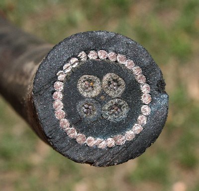
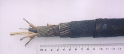
Details of the mining 'tail' cable. The
longitudinal view (below) shows that the tail cable consists of four cores of 7
strands of 0.029" tinned copper wire laid up with a central square of white
rubber and enclosed in a single layer of india rubber wrapped in a layer of
waterproof tape. This is then covered with 28 galvanised steel armour wires
(each 2.8 mm diameter). Then there is a braiding of two layers of dressed hemp
yarn wound in opposite directions wrapped over hot pitch and resin, and finally
a preservative coating. Final diameter 28 mm. The guard loop cable is not shown as
none has been recovered from Fort Bribie. A 4-core able was typical up to 1939 but
then the Adm. Patt. 660 (7-core) cable became standard. Pictures of this cable
and the Patt. 7048 are on my Cablemakers
website.
 |
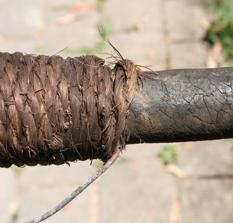 |
| Cross-sectional view of RN Adm Patt 660 Controlled Mining 'Tail' Cable (sample from Moreton Bay, Australia, laid 1943). The outer dressing of hemp yarn has perished. Diameter is 30 mm. | The jute binding is as good as new after 70 years. The galvanised wire on the bottom is used to secure the cables to the wall. The rubber has surface cracks but is still waterproof. |
 |
 |
Longitudinal view of RN Controlled Mining 'Tail'
Cable. In this sample the outer dressing of hemp yarn is clearly
visible. |
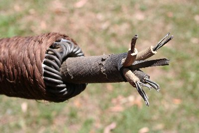
A "laid-up" end of the cable,
complete with jute bindings. |
Operation of the Controlled Mining Station at Fort Bribie

The men stationed at the CM station had to perform daily and weekly tests on the equipment to make sure it was in good working order and had to record perturbations ("perts" - the swings of the galvanometer spot due to the tides) every 5 minutes to the hour. These had to be recorded in the log book. At the end of each watch, the Handbook of Controlled Mining Confidential Book (CB) had to be mustered and had to be locked in a CB chest and then placed in a locked cupboard.
The guard loops were to the north of the mine loop so that if a submarine entered the bay it would cross the guard loop first and alert the CM operators. If a swing was detected on the guard loop, the operator would close the control switch to start the 300V generator and then ring one long bell to the power hut. The operator would then ring the Battery Observation Post (BOP) and report "Mines to Active" and would say the number of the guard loop giving the swing. He would then check to see if the correct voltage was showing on the voltmeter. Then they had to wait.
If a swing was detected on the mine loop after a swing on a guard loop it meant that a submarine had passed over the loops. The operator would then report to the BOP "Mines to Active" again, shift the selector switch to the number of the mine loop involved and fire the mines as the galvanometer spot crossed it's zero after it's first displacement. He would then ring the BOP and say "Mines to Active, mine number XX fired". After 5 seconds, the firing release lever would be released and the selector switch replaced. If there was just a swing on the guard loop they took no chances. The operator would fire anyway. After a firing took place, the fuses in the mine cable would be replaced. Of course, if a boat was sweeping for mines in the area, they should have told the XDO of the fact. In the three years of operation, the mines were never detonated. As Capt. John Campbell of the Atreus said "make sure you look at it if they are ever detonated - it'll be a spectacular show". Quoted by Sapper Graeme Jenkinson RAE Fortress Engineeers.
NAVAL OBSERVATION POST
GPS co-ordinates: S26°51.475'
E153°07.781'.

Naval Observation Post
is about 30 m to the North of the Mine Control Huts. It
comprises a small concrete floor slab on
supporting walls about 2 metres high. A partial wall stands on top around two
sides. In 1994, the Department of Environment and Heritage
bolted a galvanised steel brace to the other side of the top part for safety.


