AND HARBOUR DEFENCES OF THE ROYAL AUSTRALIAN NAVY IN MORETON BAY
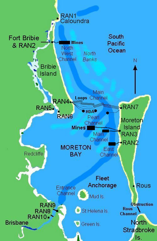
This is the story of the Royal Australian Navy's anti-submarine fixed harbour defences in Moreton Bay, Queensland, Australia during World War 2. They included indicator loops, guard loops, controlled minefields, harbour defence ASDICs, anti-submarine obstructions and booms, and photo-electric beams.
These were located at several naval installations in and around Moreton Bay. The following links will take you to more detailed descriptions and photos:
- RAN 1: Port War Signal Station (PWSS), "Buena
Vista", Wickham Point, Caloundra
- RAN 2(A): Controlled Mining and Guard Loop Station at
Tangalooma;
- RAN 2(B): Controlled Mining and Guard Loop Station at
Fort Bribie;
- RAN 3:
Controlled Mining and Guard Loop Station at Cowan Cowan, Moreton Island
(includes Fort Cowan and Fort Rous fortifications also on Moreton Island;
- RAN 4: Indicator Loop and Harbour Defence ASDIC Station at Woorim, Bribie Island;
- RAN 5: Combined Training Centre
(Naval Wing), Toorbul
- RAN 6: Advanced Fairmile Base (AFMB), Bongaree, Bribie Island;
- RAN 7: Indicator
Loop and Harbour Defence ASDIC Station at Comboyuro Point, Moreton Island;
- RAN 8: Boom Defence Facility:
Anti-submarine Boom across the Brisbane River between Lytton and Bulwer Island;
- RAN 9: Indicator Loop and Photo-electric beam Station, Myrtletown;
- RAN 10: Naval Store, Pinkenba.
- Fort Bribie, including RAN 2 Controlled Mining Station.
- Fort Bribie Underground Hospital
- Skirmish Battery, Woorim, Bribie Island
- Toorbul Radar Station No. 210 - run by the RAAF
 |
If you have any feedback please email me: Dr Richard Walding Research Fellow - School of Science Griffith University Brisbane, Australia Email: waldingr49@yahoo.com.auont> Home Phone: 61 07 32064976 69 Summit Street, Sheldon, Q, 4157, Australia |
Go to the end for a location map. This page was updated on 15 August 2022.
LINKS TO SOME OF MY RELATED PAGES:
Indicator Loops - an overview (YouTube, 70 minutes)
- Indicator Loops around the World (Home Page)
- How an indicator loop works
- Oban Bay (Scotland) indicator loop station
- United States Navy Indicator Loop Receiving Stations
MORETON BAY AT A GLANCE
From Caloundra in the north, the bay stretches some 100 miles (160 km) to Southport, encompassing some 360 islands of varying size within its boundaries. Emptying into Moreton Bay is the Brisbane River upon which is situated Brisbane, Capital city of the State of Queensland. The map below shows the main features of the bay.

-
Richard Walding, Brisbane, Australia.