
Woody Island Anti-submarine Loop Station
Another of the US Navy
Indicator Loop Stations was operated at Woody Island, Kodiak, Alaska, USA.

|
If you have any feedback please email me: Dr Richard Walding Research Fellow - School of Science Griffith University Brisbane, Australia Email: waldingr49@yahoo.com.au |
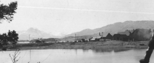
The photo below is
of the "Naval Net Depot" at Woody Island. It was taken by Elmer Aemmer in 1942.
On the left is the loop station consisting of the main loop building (24' x 28')
and the loop generator hut (9' x 12') to its right. The loop officers' quarters
- obscured by the trees - was a 30' x 12' wooden building joined to the loop hut
by a wooden walkway. On the right of the photo is the shop, the school and
teachers' house, a variety of sheds and a power house. The photo comes from the
excellent
Woody Island Military History site.

SHORT
HISTORY
Woody Island is about 2.6 miles east of Kodiak, mid-way along the southern coast
of Alaska (Lat 57°47' N, Long 152° 20' W). The Russians used Woody Island as an agricultural colony as
early as 1792. In 1911 the US Navy built a wireless station on the island and
with Japanese expansion in the Aleutian Island Chain, the island's importance
increased. In 1939, the US Navy occupied quarters on
West Woody Island and the
Federal Aviation Agency shifted its facilities from West Woody to East Woody
Is.. In December 1942 anti-submarine magnetic indicator loop stations were
installed on the island. Two sets of loop cables were laid: the smaller loop was
laid between Woody Island and Kodiak Island, about midway along the channel
between the two islands; the larger loop ran between the tip of Cliff Point and
the southern tip of Woody Island. In November 1943, anti-torpedo nets, 30' deep,
for protection against the torpedo rather than the submarine, were substituted
for the heavier nets laid in October 1942. After the war, the naval station
continued to serve as a navigational station but in 1973 the station became
unmanned.

A section of the map of the US Naval Reserve at Woody Island. Original scale 1"
= 100 feet, NAS Drawing No. K-3-14, 120, drawn April 4, 1944, revised 2 December
1952.
A RECENT PHOTO

· Return to our
US Navy Loop Receiving Station web page
My other anti-submarine indicator loop pages: